Loading this page…

Loading this page…
Marina service
About
Lady Nelson Wharf is a useful Port Macquarie waterfront stop, connecting boaters with the Hastings River and the town’s lively foreshore.
Service area: Port Macquarie (Town Green, access via Horton Street)
Keep exploring
Located on the Hastings River, Lady Nelson Wharf provides public access in a central Port Macquarie setting. It is a practical point for suitable vessels to pause while crews enjoy the riverfront and town nearby.
The public wharf supports short-term access rather than a full marina stay, with shops, dining and local services available ashore.
The Hastings River invites calm-water exploration, fishing and scenic cruising, while Port Macquarie’s beaches and coastal attractions are close by.
Satellite imagery at four heights, from the wider harbour to the berths.
Recently received AIS vessel positions around Lady Nelson Wharf. The traffic display loads automatically.
Live traffic will appear after Lady Nelson Wharf has verified map coordinates.
Batemans Bay and the Clyde River form a classic NSW South Coast cruising region where a sheltered, tidal estuary meets a short, island‑dotted entrance to the Tasman Sea. It’s distinctive for easy access from Canberra, a mix of river and bay sailing, a compact marina and mooring network, and a river entrance (the Clyde River bar) that can change rapidly. The area suits day sails, weekend cruising, trailer‑boat exploration and sheltered coastal passages; offshore or long‑passage plans require careful timing and local knowledge. Preparation for tidal flow, variable southerly swells and shallow, s

Expect light to moderate, thermally-driven sea breezes in summer with afternoon strengthening; more changeable and often stronger winds with frontal systems in autumn and spring; and the windiest, roughest conditions in winter when cold fronts and sou’westers are most frequent. Gulf St Vincent is more sheltered than the exposed coast but can still produce steep chop and sudden changes near Adelaide and headlands.
Explore →
Pick a protected bay, estuary or river reach where you can rig, launch and arrive on calm water within a short, sheltered transit; choose a site with a good ramp or jetty, clear recovery options and a nearby sailing club, marina or commercial operator for local knowledge and help.
Explore →
Plan as a chain of conservative daily legs tied to your boat’s real-world fuel and speed in the expected sea state, with confirmed primary and alternate anchorages/berths, fuel legs and back-up fuel options, and a documented emergency/diversion plan (comms, tow and med-evac). Build tidal and weather gates into each leg and carry chart and comms redundancy.
Explore →
Plan passages across Spencer Gulf or to Kangaroo Island by basing fuel on your boat’s actual consumption plus a generous reserve, choosing sensible staging/stop options that match your boat and crew, and prioritising shelter and weather windows (gale fronts, strong winds and tidal streams can make the gulf uncomfortable or unsafe). Confirm fuel availability, safe anchorages or marinas on your route, and check up-to-date local weather, tide and navigation information before you go.
Explore →A practical guide for recreational sailors planning visits to Albany and King George Sound. Covers the main anchorage areas, typical local weather patterns, tidal and current considerations, navigational hazards, on-the-water etiquette and a pre-departure checklist to help you plan a safe passage and enjoyable stopover
Explore →Practical guide for recreational sailors planning passage on the Hawkesbury River: how to plan around tides, choose anchorages, read local conditions and prepare the boat and crew for a safe, comfortable trip.
Explore →
Practical guidance for recreational sailors in Australia on assessing swell, tide and wind, choosing the safest time to cross a coastal bar, preparing crew and gear, and making the decision to go or turn back.
Explore →A practical guide for recreational sailors planning day sails or short cruises around Batemans Bay, Broulee and the Clyde River. Covers local conditions, safe approaches, anchorages, launching, tides, common hazards, and checklists for trip planning and on-water decisions.
Explore →Burke Yachtsman Gear Bag 40L - Shop Now Zip Pay | Tamar Marine Skip to content 59 – 63 Holbrook Street, Invermay Online Shop Open 24/7 Products search Contact us 1300 MARINE $ 0.00 0 Cart Burke Yachtsman Gear Bag 40L $ 79.90 Colour Choose an option Black Blue Black Blue Clear - Burke Yachtsman Gear Bag 40L quantity + Add to cart Enquire about this product SKU BAGB-Y24/BLACK* Category Bags - Sail & Gear A Burke classic and customer favourite, the Yachtsman’s Gear Bag is built tough to handle wet, salty conditions while keeping your gear dry and protected. Made from double coated waterproof…
Explore →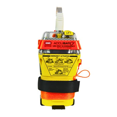
A 10‑year battery EPIRB with integrated GNSS (supports GPS and Galileo), infrared strobe and 121.5 MHz homing signal. Approved for worldwide COSPAS‑SARSAT operation.
Explore →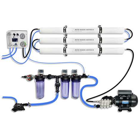
A three-membrane modular watermaker with 200 L/h nominal output and up to 240 L/h family-level marketing, for larger crews and heavy use.
Explore →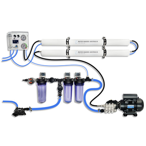
A two-membrane modular watermaker with 140 L/h nominal output, aimed at families and liveaboards that want more water per run.
Explore →