Loading this page…

Loading this page…
Marina service
About
Onslow Beadon Creek Maritime Facility supports resources, fishing, charter and recreational vessels with pile mooring pens, a service wharf, dual boat ramp and fuel.
Service area: Onslow, WA (Pilbara)
Keep exploring
Use this listing for the government-managed Beadon Creek facility at Onslow. WA Transport describes eight pile mooring pens, a service wharf, dual public boat ramp, fuelling facility, fish-cleaning table and public car park. It is a practical Pilbara working facility with offshore-industry, charter, fishing and recreational users.
The berthing core of the facility is ten berths on mooring piles in Beadon Creek, referred to as The Sticks, allocated on permanent arrangements largely to commercial, charter and fishing operators; transient recreational berthing is limited and should be arranged with the department in advance. The 50-metre service wharf provides single-phase and three-phase power and water, and its fuelling facility is operated by Baileys Marine Fuels on a fuel-card basis (phone 1300 224 539), dispensing diesel to vessels at the wharf.
Published load limits for the wharf allow berthing of vessels up to 50 tonnes displacement at a maximum approach speed of 0.3 metres per second, with stack loads of 750 kilograms per square metre and M9 vehicle loading, which comfortably covers the charter boats and small workboats that use it. The Community Boating Precinct has modernised the launching side: a dual-lane concrete ramp with an all-tide floating jetty offering more than 40 metres of berthing space on both sides, a sealed car and boat-trailer park with solar lighting, a fish cleaning table near the ramp, and public amenities added in the final Stage 1 works in 2023.
The Stage 1 project dredged about 45,000 cubic metres from the creek bed to form a deeper basin protected by rock revetments incorporating some 20,000 tonnes of granite and recovered rock. There is no slipway, travel lift or hardstand at the facility; heavy marine support, including craneage up to 800 tonnes, laydown areas and fuel bunkering, is available commercially at the adjacent Onslow Marine Support Base for vessels up to 110 metres.
Detailed design for Stage 2, fully serviced pens, more public jetties and ablutions, has been completed by engineering firm Advisian, but construction awaits funding. Cyclone mooring arrangements and dredged-depth notices are published by the department and should be checked before arrival.
Beadon Creek is a tidal creek on a coast where tides run to several metres, and the entrance channel requires regular dredging; the department publishes cyclone community information sheets with current dredged depths, and strangers should take them seriously rather than trusting charted soundings. The approach from seaward is across open Indian Ocean water with offshore shoals, and the creek entrance can break in swell, so arrivals are best timed for the top of the tide in settled weather.
Inside, the creek is sheltered in all conditions short of a cyclone, and Onslow's reputation as a cyclone town means mooring discipline is taken seriously; the pilings at The Sticks and the cyclone-rated revetments exist for a reason. Fishing is the reason most private boats come here: the Mackerel Islands lie within trailer-boat range offshore, the creek mouths and flats hold threadfin salmon, mud crabs and barramundi-scale mangrove jack, and the ramp car park on a winter weekend testifies to a recreational boat ownership rate the Shire quotes at 70 vessels per 1,000 people.
Provisioning in town covers the essentials, a supermarket, fuel, a tavern and accommodation geared partly to the fly-in workforce, but specialist marine supplies are thin; anything beyond filters and fasteners means a trip to Karratha, about 250 kilometres northeast, or freight in. Fuel for boats is by Baileys card at the service wharf, so arrange the card before arriving. The surrounding coast is remote in the Pilbara sense: long distances, corrugations on station tracks, and no other serviced boating facility until Exmouth or Karratha.
For visitors towing a boat 1,300 kilometres up from Perth, the practical advice is simple: arrive self-sufficient, time the tides, and expect to share the ramp with cray boats and gas-field crew boats.
Satellite imagery at four heights, from the wider harbour to the berths.
Recently received AIS vessel positions around Onslow Maritime Facility. The traffic display loads automatically.
Live traffic will appear after Onslow Maritime Facility has verified map coordinates.
American River (Kangaroo Island, SA) is a small, sheltered inlet and township on the north‑eastern side of Kangaroo Island that acts as a calm staging point for cruising the eastern part of the island and for short hops through Backstairs Passage. It’s distinctive for its protected anchorage inside Eastern Cove and the adjacency of Pelican Lagoon — a shallow, ecologically important lagoon with sanctuary zoning — which shapes how and where boats can move. The area suits sheltered day sailing, weekend cruising and short coastal passages; it’s appropriate for trailer sailors, small cruisers and a

Use ramps and beaches with respect for local conditions: check ramp layout, tide and swell, wind direction, vehicle access and crowding; prepare boat and crew before you launch or retrieve; and follow local signage, courtesy and safety practices. Specifics vary by ramp and beach, so confirm details for the exact site before you go.
Explore →
Plan passages across Spencer Gulf or to Kangaroo Island by basing fuel on your boat’s actual consumption plus a generous reserve, choosing sensible staging/stop options that match your boat and crew, and prioritising shelter and weather windows (gale fronts, strong winds and tidal streams can make the gulf uncomfortable or unsafe). Confirm fuel availability, safe anchorages or marinas on your route, and check up-to-date local weather, tide and navigation information before you go.
Explore →
Pick a ramp that matches your boat size and trailer setup, has safe approach and exit conditions (depth, slope, surface), good onshore parking and flow, and follow simple ramp etiquette: queue, help others, rig off the trailer when clear, and secure your vessel quickly.
Explore →
Tidal streams and local wind patterns can change trip time, fuel use, helm balance and safety margins on short coastal runs — plan your departure and route to use favourable tidal flow, allow margin for wind-driven sea and gusts, and check up-to-date local tide and weather information before you go.
Explore →A practical guide for recreational sailors planning voyages to Esperance and the Recherche Archipelago: what to expect, key planning considerations, common anchorages, safety and communications, equipment recommendations and sensible steps for a successful trip in this remote southern WA cruising area.
Explore →Practical guide for recreational sailors planning passage on the Hawkesbury River: how to plan around tides, choose anchorages, read local conditions and prepare the boat and crew for a safe, comfortable trip.
Explore →A concise, practical introduction to the essential parts of a recreational sailing boat for beginners in Australia. Covers hull, deck, rigging, sails, steering, below-decks spaces and safety equipment, with simple explanations, common mistakes and a pre-decast checklist to help new sailors communicate and get underway.
Explore →A practical guide for recreational sailors planning visits to Albany and King George Sound. Covers the main anchorage areas, typical local weather patterns, tidal and current considerations, navigational hazards, on-the-water etiquette and a pre-departure checklist to help you plan a safe passage and enjoyable stopover
Explore →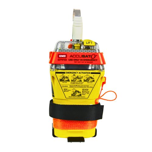
A 10‑year battery EPIRB with integrated GNSS (supports GPS and Galileo), infrared strobe and 121.5 MHz homing signal. Approved for worldwide COSPAS‑SARSAT operation.
Explore →
Self-contained, battery-powered plug‑and‑play autopilot designed for standard hydraulic steering systems.
Explore →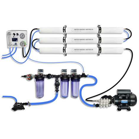
A three-membrane modular watermaker with 200 L/h nominal output and up to 240 L/h family-level marketing, for larger crews and heavy use.
Explore →Burke Yachtsman Gear Bag 40L - Shop Now Zip Pay | Tamar Marine Skip to content 59 – 63 Holbrook Street, Invermay Online Shop Open 24/7 Products search Contact us 1300 MARINE $ 0.00 0 Cart Burke Yachtsman Gear Bag 40L $ 79.90 Colour Choose an option Black Blue Black Blue Clear - Burke Yachtsman Gear Bag 40L quantity + Add to cart Enquire about this product SKU BAGB-Y24/BLACK* Category Bags - Sail & Gear A Burke classic and customer favourite, the Yachtsman’s Gear Bag is built tough to handle wet, salty conditions while keeping your gear dry and protected. Made from double coated waterproof…
Explore →