Loading this page…

Loading this page…
Marina service
About
The Quays Marina at Church Point offers 110 berths and 69 moorings, fuel, tender service, pump-out, 24-hour amenities and extensive repair support on Pittwater.
Service area: Church Point, Pittwater, NSW
Keep exploring
The marina provides owners with a practical home port and an inviting place to begin regular days on the water.
Diesel and unleaded fuel are available seven days a week, with the fuel wharf accepting vessels up to 80 feet. The marina also provides a pump-out beside the fuel wharf, power and fresh water, 24-hour toilets and showers, trolleys, ice, gas and oil. A scheduled tender serves mooring customers, with dinghies available after hours. Surveillance systems and overnight security patrols protect the site, and the marina café provides waterside dining.
Church Point is a busy gateway to Scotland Island, western Pittwater and the bays leading towards Broken Bay. Expect ferries, tenders, moored vessels and concentrated weekend traffic around the wharf precinct. From the marina, crews can remain in sheltered Pittwater or plan coastal passages through Broken Bay, subject to current weather and sea conditions. Shops and food are available around Church Point.
Satellite imagery at four heights, from the wider harbour to the berths.
Recently received AIS vessel positions around The Quays Marina. The traffic display loads automatically.
Live traffic will appear after The Quays Marina has verified map coordinates.
Bathurst Harbour (Port Davey system), in south‑west Tasmania, is a vast, almost land‑locked estuarine harbour inside the Southwest National Park and World Heritage Area. It offers a remote, sheltered anchoring environment protected from the Roaring Forties, but demands careful planning, an awareness of marine‑reserve rules, and a willingness to operate in shallow, tannin‑stained waters. Best suited to experienced coastal cruisers and small expedition yachts prepared for self‑sufficiency, Bathurst Harbour is more a place to linger and explore on foot and by tender than a port of call for busy,

Plan passages across Spencer Gulf or to Kangaroo Island by basing fuel on your boat’s actual consumption plus a generous reserve, choosing sensible staging/stop options that match your boat and crew, and prioritising shelter and weather windows (gale fronts, strong winds and tidal streams can make the gulf uncomfortable or unsafe). Confirm fuel availability, safe anchorages or marinas on your route, and check up-to-date local weather, tide and navigation information before you go.
Explore →
Plan as a chain of conservative daily legs tied to your boat’s real-world fuel and speed in the expected sea state, with confirmed primary and alternate anchorages/berths, fuel legs and back-up fuel options, and a documented emergency/diversion plan (comms, tow and med-evac). Build tidal and weather gates into each leg and carry chart and comms redundancy.
Explore →
A good float plan and a well-stocked emergency kit significantly improve your chances of a safe outcome when cruising remote parts of South Australia’s coastline. The float plan should give someone ashore all the information they need to find you and raise help if you don’t return; the emergency kit should allow you to stabilise the boat, care for injuries, signal for rescue and survive until help arrives.
Explore →
Expect light to moderate, thermally-driven sea breezes in summer with afternoon strengthening; more changeable and often stronger winds with frontal systems in autumn and spring; and the windiest, roughest conditions in winter when cold fronts and sou’westers are most frequent. Gulf St Vincent is more sheltered than the exposed coast but can still produce steep chop and sudden changes near Adelaide and headlands.
Explore →A practical guide for recreational sailors planning visits to Albany and King George Sound. Covers the main anchorage areas, typical local weather patterns, tidal and current considerations, navigational hazards, on-the-water etiquette and a pre-departure checklist to help you plan a safe passage and enjoyable stopover
Explore →A practical guide to preparing, planning and executing a recreational offshore passage along the New South Wales coast. Covers route selection, weather and tidal considerations, vessel and crew checks, safety equipment, communication, watchkeeping and common mistakes, with clear pre‑departure and underway checklists.
Explore →
A practical, Australia-focused guide for planning and sailing around the Whitsunday Islands: weather and seasons, navigation and anchoring, moorings and parks, provisioning and charters, safety and common mistakes, plus checklists and next steps.
Explore →Practical guidance for recreational sailors in New South Wales on navigating marine parks, using moorings and anchoring responsibly. Covers how to plan passages, approach moorings, set and retrieve an anchor, minimise environmental impact and follow local rules.
Explore →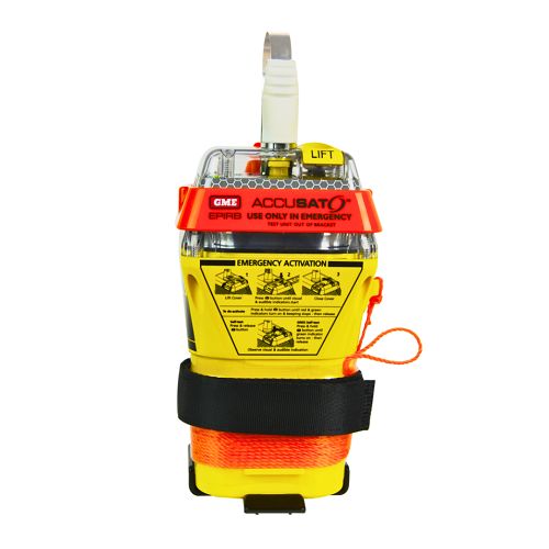
A 10‑year battery EPIRB with integrated GNSS (supports GPS and Galileo), infrared strobe and 121.5 MHz homing signal. Approved for worldwide COSPAS‑SARSAT operation.
Explore →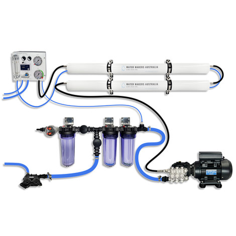
A two-membrane modular watermaker with 140 L/h nominal output, aimed at families and liveaboards that want more water per run.
Explore →
Self-contained, battery-powered plug‑and‑play autopilot designed for standard hydraulic steering systems.
Explore →Burke Yachtsman Gear Bag 40L - Shop Now Zip Pay | Tamar Marine Skip to content 59 – 63 Holbrook Street, Invermay Online Shop Open 24/7 Products search Contact us 1300 MARINE $ 0.00 0 Cart Burke Yachtsman Gear Bag 40L $ 79.90 Colour Choose an option Black Blue Black Blue Clear - Burke Yachtsman Gear Bag 40L quantity + Add to cart Enquire about this product SKU BAGB-Y24/BLACK* Category Bags - Sail & Gear A Burke classic and customer favourite, the Yachtsman’s Gear Bag is built tough to handle wet, salty conditions while keeping your gear dry and protected. Made from double coated waterproof…
Explore →