Loading this page…

Loading this page…
About
Two Rocks Marina is a government-managed marina serving recreational and rock-lobster vessels, with boat pens, marina facilities and redevelopment/jetty works forming part of the harbour context.
Service area: Two Rocks, WA
Keep exploring
Use this listing for the Two Rocks marina facility north of Perth. WA Transport identifies marina facilities and boat pens serving the rock-lobster industry and recreational vessels. Redevelopment material also references replacement floating jetty works and boat-pen capacity. Users should confirm current pen availability, access and construction impacts before arrival.
The marina holds 125 boat pens serving recreational owners and the commercial rock lobster fleet, arranged around a service wharf and jetty fitted with single and three-phase power, water and lighting. Diesel is available 24 hours a day, seven days, supplied by Bailey's Marine Fuels on a fuel-card basis through Ampol; there is no casual bowser petrol, so plan fuel before you leave Perth.
The boat lifting yard runs a 40-tonne lifter, a 1995 Cummins unit, rated for vessels up to 22 metres long with a 7.1-metre beam, and lifting slots are booked through DTMI on 1300 863 308 during weekday office hours or via the dedicated lifter email. Around the lift well sits a large asphalt hardstand used for vessel and trailer storage, with wash-down areas and a water-blasting service, forklift and operator hire, and power and water laid on to hardstand positions.
Trailer boaters get a concrete two-lane launching ramp with a floating jetty on the southern side of the harbour, a universal access pontoon to its north reserved for recreational and emergency vessels, and parking for 82 car-and-trailer rigs plus 57 cars. Pen holders have their own toilets, showers and laundry, while a public universal-access toilet block stands near the ramp. Fees follow the department's published maritime facilities schedule, and casual berthing is available when pens are free.
Commercial leasing rounds out the mix, and contract lifter operators keep the yard running day to day. The one live navigational caveat the department publishes is a build-up of sand inside the entrance, which has cut both depths and channel width.
Two Rocks faces the open Indian Ocean with nothing between the breakwater and Africa, so passage planning starts with the swell forecast. The entrance channel sits at roughly 31.495 south, 115.580 east, and DTMI's standing advice about sand build-up inside the entrance means deeper-keeled boats should favour the top half of the tide and watch the leads. There is no island shelter here; when the summer sea breeze stands in from the south-west at 20 knots, the run home is square into it.
The reward offshore is serious fishing: dhufish, pink snapper and samson fish on the inshore reefs, cray pot country within sight of the tower blocks that never quite arrived, and tuna and marlin for those running wider. The cray fleet works from the harbour through the season, and their comings and goings set the mood on the wharf. Ashore, the Sun City Yacht Club, founded in the Bond years, runs summer programs from the marina, and the restored King Neptune statue on the ridge makes a useful navigation mark from seaward.
Yanchep Lagoon, a few minutes south, is the local snorkelling and swimming spot when the ocean is up. Provisioning is modest at the Two Rocks shops, so most crews stock up at Yanchep or Butler on the drive north. Hillarys Boat Harbour, 40-odd kilometres down the coast, is the fallback when the weather turns, and Rottnest lies roughly 50 kilometres offshore to the south-west for a longer day run in settled conditions.
Fuel of the petrol variety, bait and ice are limited close to the ramp, so the standard local routine is to arrive with tanks full and the esky loaded, then top the diesel by card at the service wharf on the way home.
Satellite imagery at four heights, from the wider harbour to the berths.
Recently received AIS vessel positions around Two Rocks Marina. The traffic display loads automatically.
Live traffic will appear after Two Rocks Marina has verified map coordinates.
Batemans Bay and the Clyde River form a classic NSW South Coast cruising region where a sheltered, tidal estuary meets a short, island‑dotted entrance to the Tasman Sea. It’s distinctive for easy access from Canberra, a mix of river and bay sailing, a compact marina and mooring network, and a river entrance (the Clyde River bar) that can change rapidly. The area suits day sails, weekend cruising, trailer‑boat exploration and sheltered coastal passages; offshore or long‑passage plans require careful timing and local knowledge. Preparation for tidal flow, variable southerly swells and shallow, s

Plan to use tide and local knowledge, slow and steerable power, and deliberate positioning to work with—rather than fight—strong streams and eddies when entering or leaving Tasmanian harbours.
Explore →
A regular, layered maintenance routine combining hull cleaning, targeted anti-fouling management, cathodic protection and systems checks will substantially reduce marine growth and corrosion for boats kept year‑round in South Australian waters. Focus on preventing attachment and electrochemical attack, then inspect and act more often if you’re in warm, nutrient-rich or high‑traffic sheltered waters.
Explore →
Use ramps and beaches with respect for local conditions: check ramp layout, tide and swell, wind direction, vehicle access and crowding; prepare boat and crew before you launch or retrieve; and follow local signage, courtesy and safety practices. Specifics vary by ramp and beach, so confirm details for the exact site before you go.
Explore →
Pick a stable, simple, forgiving dinghy with a single sail or basic sloop rig, affordable handling and easy maintenance—ideally one with a local class or school nearby so you can access coaching and spare parts.
Explore →A concise, practical introduction to the essential parts of a recreational sailing boat for beginners in Australia. Covers hull, deck, rigging, sails, steering, below-decks spaces and safety equipment, with simple explanations, common mistakes and a pre-decast checklist to help new sailors communicate and get underway.
Explore →
A practical checklist and explanation of the safety equipment recreational sailors should carry in Australian waters, with how to choose gear, use it correctly, and common mistakes to avoid.
Explore →A practical guide for recreational sailors planning voyages to Esperance and the Recherche Archipelago: what to expect, key planning considerations, common anchorages, safety and communications, equipment recommendations and sensible steps for a successful trip in this remote southern WA cruising area.
Explore →A practical guide for recreational sailors planning passages to, from or around Eden and Twofold Bay. Covers sheltered anchorages, shore facilities, local weather and tidal considerations, preparing for Bass Strait conditions and a focused equipment and safety checklist.
Explore →
Self-contained, battery-powered plug‑and‑play autopilot designed for standard hydraulic steering systems.
Explore →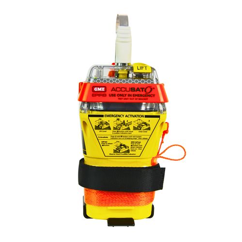
A 10‑year battery EPIRB with integrated GNSS (supports GPS and Galileo), infrared strobe and 121.5 MHz homing signal. Approved for worldwide COSPAS‑SARSAT operation.
Explore →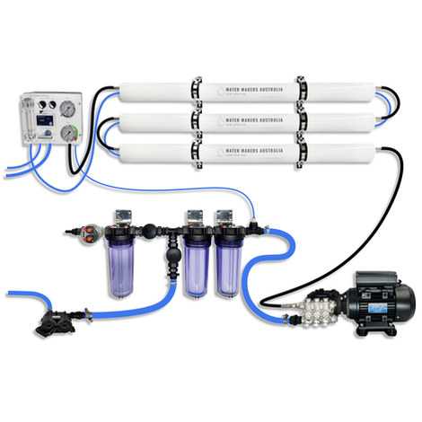
A three-membrane modular watermaker with 200 L/h nominal output and up to 240 L/h family-level marketing, for larger crews and heavy use.
Explore →Burke Yachtsman Gear Bag 40L - Shop Now Zip Pay | Tamar Marine Skip to content 59 – 63 Holbrook Street, Invermay Online Shop Open 24/7 Products search Contact us 1300 MARINE $ 0.00 0 Cart Burke Yachtsman Gear Bag 40L $ 79.90 Colour Choose an option Black Blue Black Blue Clear - Burke Yachtsman Gear Bag 40L quantity + Add to cart Enquire about this product SKU BAGB-Y24/BLACK* Category Bags - Sail & Gear A Burke classic and customer favourite, the Yachtsman’s Gear Bag is built tough to handle wet, salty conditions while keeping your gear dry and protected. Made from double coated waterproof…
Explore →