Loading this page…

Loading this page…
Marina service
About
Abel Point Public Boat Ramp & Pontoon is the sheltered Airlie Beach launch facility off Shingley Drive, with two ramp lanes and pontoon/floating walkway access beside Coral Sea Marina.
Service area: Airlie Beach, Whitsundays, QLD
Keep exploring
Use this listing for public launching at Abel Point, not a full-service marina. Local and tourism sources describe an all-weather public ramp with floating walkways/pontoons on the northern edge of Airlie Beach, useful for Whitsundays trailer boats and tender access.
Services at Abel Point are exactly what Queensland's public marine facility framework provides, and no more, which is worth spelling out for anyone arriving with expectations shaped by the resort marina next door. The core asset is a two-lane concrete boat ramp recorded in the state registry as usable at all tides, with a floating walkway running alongside for crew boarding and a separate pontoon where boats can hold while trailers are retrieved or parked.
A canoe and kayak ramp gives paddlers their own access point away from the trailer traffic, and a water tap is provided for engine flushing and washdown. Parking is the chronic pinch point: the registry lists only around 18 formal carparks against the ramp, and council and EIS commentary going back two decades notes the car and trailer parking is over-utilised, full most days in season.
There are no toilets, fish-cleaning tables or lighting listed against the facility in the registry, and no fuel, berthing, slipway or waste services of any kind; those needs are met commercially a few hundred metres away inside Coral Sea Marina, where a 24-hour fuel wharf, pump-out and full boatyard operate, or at Port of Airlie at the other end of town. Use of the ramp is free, as it is a listed public marine facility under state transport infrastructure regulation, owned by Transport and Main Roads and managed by Whitsunday Regional Council, which handles cleaning, repairs and ramp rules.
There is no on-site security or staffing; boaties self-manage, and the usual etiquette of queuing on the pontoon applies. For anything mechanical, chandlery and marine trades cluster around the two commercial marinas within a few minutes' drive.
The run from ramp to open water here is short and forgiving. Launching puts you straight into the lee of the Coral Sea Marina breakwater on Pioneer Bay, and a few minutes at low speed clears the marina entrance before the Whitsunday Passage opens up ahead. Tidal range in this part of the Whitsundays runs to around three metres on springs, and while the ramp itself is not tide dependent, the bay outside can be lumpy in a fresh south-easterly; the trade winds blow hard from May to September, which is precisely when trailer traffic peaks.
From Abel Point the popular first legs are Hook Passage and Hook Island to the north-east, Whitehaven Beach on Whitsunday Island roughly 15 nautical miles away, and the sheltered anchorages of Cid Harbour and Nara Inlet for overnighters. Local fishers work the fringing reefs around Hook and the Molle islands for coral trout and sweetlip, and mackerel show up along the pressure edges in winter.
Practical knowledge matters most on land: arrive before seven on weekends and school holidays or expect to circle for a trailer park, and note that overflow options are limited since the Port of Airlie ramp, built as part of that marina's development with around 45 car-trailer spaces, is the nearest alternative, with a newer council ramp at Altmann Avenue in Cannonvale further south.
Cyclone season runs November to April and the bay is a known cyclone anchorage, so the ramp gets hectic whenever a warning is issued as owners retrieve trailer boats ahead of a blow.
Satellite imagery at four heights, from the wider harbour to the berths.
Recently received AIS vessel positions around Abel Point Public Boat Ramp & Pontoon. The traffic display loads automatically.
Live traffic will appear after Abel Point Public Boat Ramp & Pontoon has verified map coordinates.
Adelaide’s metropolitan coast fronts the eastern side of Gulf St Vincent and mixes short, sheltered bay sailing around Holdfast Bay and the Patawalonga with more exposed, open-water sailing north toward Outer Harbour and along the Le Fevre Peninsula. The area suits a wide range of activity — sheltered day sails, club and trailer-sailer racing, short coastal cruising into the Fleurieu and Yorke Peninsula, and launch-and-home-port racing — but demands local knowledge about shipping channels, tidal flows in the Port River/Outer Harbour approaches, and seasonal wind patterns.

Use ramps and beaches with respect for local conditions: check ramp layout, tide and swell, wind direction, vehicle access and crowding; prepare boat and crew before you launch or retrieve; and follow local signage, courtesy and safety practices. Specifics vary by ramp and beach, so confirm details for the exact site before you go.
Explore →
Pick a ramp that matches your boat size and trailer setup, has safe approach and exit conditions (depth, slope, surface), good onshore parking and flow, and follow simple ramp etiquette: queue, help others, rig off the trailer when clear, and secure your vessel quickly.
Explore →
Pick a protected bay, estuary or river reach where you can rig, launch and arrive on calm water within a short, sheltered transit; choose a site with a good ramp or jetty, clear recovery options and a nearby sailing club, marina or commercial operator for local knowledge and help.
Explore →
Rig and de-rig a small dinghy by following a consistent, step-by-step sequence: prepare the boat on shore, fit spars and foils in a stable order, control sails and running rigging so lines don’t tangle, check fittings and safety gear, and reverse the process when coming ashore—always working with a partner when possible and staying aware of wind and tide.
Explore →
A practical guide for new sailors on picking the right Australian sailing club: training, boat access, racing, social fit, costs and the key questions to ask before joining.
Explore →A practical guide to the coastal weather systems that affect sailing along Western Australia's coast, focusing on the Fremantle Doctor, local sea breezes, and linked coastal phenomena. Explains how these systems form, when they tend to occur, how they influence boat handling and passage planning, common mistakes, and a
Explore →Practical guide for recreational sailors planning passage on the Hawkesbury River: how to plan around tides, choose anchorages, read local conditions and prepare the boat and crew for a safe, comfortable trip.
Explore →Practical guide for recreational sailors visiting Albany and King George Sound. Covers typical weather patterns, sheltered anchorages, local hazards, tides and currents, berthing and shore access, pre-departure checks and sensible safety practices tailored to south-west Western Australia.
Explore →Burke Yachtsman Gear Bag 40L - Shop Now Zip Pay | Tamar Marine Skip to content 59 – 63 Holbrook Street, Invermay Online Shop Open 24/7 Products search Contact us 1300 MARINE $ 0.00 0 Cart Burke Yachtsman Gear Bag 40L $ 79.90 Colour Choose an option Black Blue Black Blue Clear - Burke Yachtsman Gear Bag 40L quantity + Add to cart Enquire about this product SKU BAGB-Y24/BLACK* Category Bags - Sail & Gear A Burke classic and customer favourite, the Yachtsman’s Gear Bag is built tough to handle wet, salty conditions while keeping your gear dry and protected. Made from double coated waterproof…
Explore →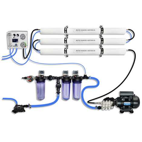
A three-membrane modular watermaker with 200 L/h nominal output and up to 240 L/h family-level marketing, for larger crews and heavy use.
Explore →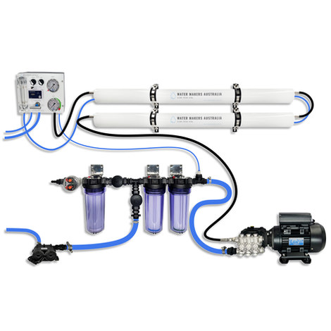
A two-membrane modular watermaker with 140 L/h nominal output, aimed at families and liveaboards that want more water per run.
Explore →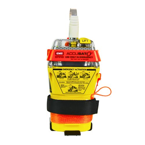
A 10‑year battery EPIRB with integrated GNSS (supports GPS and Galileo), infrared strobe and 121.5 MHz homing signal. Approved for worldwide COSPAS‑SARSAT operation.
Explore →