Loading this page…

Loading this page…
Marina service
About
MAST owns two public concrete berthing piers on Georges Bay Esplanade at St Helens. The piers have shore power, water and lighting, with a daily charge for utility services and a 70-tonne vessel-displacement limit. Toilets, parking, petrol and a marine dealer are nearby rather than onsite pier facilities.
Service area: St Helens, Georges Bay (Tasmania)
Keep exploring
The St Helens Berthing Piers are public concrete piers owned by Marine and Safety Tasmania, not a full-service recreational marina. MAST lists two piers of about 262.5 m² each, a pedestrian-only deck load limit and a 70-tonne vessel-displacement limit. Power, water and lighting are available on the structures, and MAST charges daily for utility services. Toilets, parking, petrol and marine retail are listed as nearby services. Follow posted restricted-area and loading-zone signs for maximum stays.
MAST lists shore power and water on the piers and applies a daily service charge. The deck is pedestrian-only and vessel-displacement limit is 70 tonnes. Nearby toilets, parking, petrol and a marine dealer are not onsite pier services. Confirm current berth duration and utility arrangements with MAST and obey posted restricted-area signs.
Georges Bay is a working boating area. MAST's restricted-area signs govern jetty stays and loading zones; check current notices and bar/approach conditions before entering.
Satellite imagery at four heights, from the wider harbour to the berths.
Recently received AIS vessel positions around St Helens Berthing Piers (MAST). The traffic display loads automatically.
Live traffic will appear after St Helens Berthing Piers (MAST) has verified map coordinates.
Adelaide’s metropolitan coast fronts the eastern side of Gulf St Vincent and mixes short, sheltered bay sailing around Holdfast Bay and the Patawalonga with more exposed, open-water sailing north toward Outer Harbour and along the Le Fevre Peninsula. The area suits a wide range of activity — sheltered day sails, club and trailer-sailer racing, short coastal cruising into the Fleurieu and Yorke Peninsula, and launch-and-home-port racing — but demands local knowledge about shipping channels, tidal flows in the Port River/Outer Harbour approaches, and seasonal wind patterns.

Expect light to moderate, thermally-driven sea breezes in summer with afternoon strengthening; more changeable and often stronger winds with frontal systems in autumn and spring; and the windiest, roughest conditions in winter when cold fronts and sou’westers are most frequent. Gulf St Vincent is more sheltered than the exposed coast but can still produce steep chop and sudden changes near Adelaide and headlands.
Explore →
Follow the basic COLREGs: keep a proper lookout, maintain safe speed and steering to avoid collisions, know which vessel ‘gives way’ and which ‘stands on’, use correct lights and sound signals, and keep clear of restricted waters and traffic lanes. Check local harbour rules and AMSA guidance for specifics.
Explore →
Use ramps and beaches with respect for local conditions: check ramp layout, tide and swell, wind direction, vehicle access and crowding; prepare boat and crew before you launch or retrieve; and follow local signage, courtesy and safety practices. Specifics vary by ramp and beach, so confirm details for the exact site before you go.
Explore →
There are legal obligations in Western Australia for recreational boat owners and skippers covering vessel registration, carriage of safety equipment and general skipper responsibilities, but the exact requirements depend on vessel type, size, where you sail and whether the vessel is commercial or recreational. Check the Western Australian Department of Transport (DoT WA) and the national authority for the precise checklist that applies to your boat and voyage.
Explore →A practical guide for recreational sailors planning day sails or short cruises around Batemans Bay, Broulee and the Clyde River. Covers local conditions, safe approaches, anchorages, launching, tides, common hazards, and checklists for trip planning and on-water decisions.
Explore →A practical guide for recreational sailors planning visits to Albany and King George Sound. Covers the main anchorage areas, typical local weather patterns, tidal and current considerations, navigational hazards, on-the-water etiquette and a pre-departure checklist to help you plan a safe passage and enjoyable stopover
Explore →A practical guide for recreational sailors planning passages to, from or around Eden and Twofold Bay. Covers sheltered anchorages, shore facilities, local weather and tidal considerations, preparing for Bass Strait conditions and a focused equipment and safety checklist.
Explore →A practical guide for recreational sailors on using VHF marine radios safely and effectively in Australian waters: basic operation, channel use, emergency procedures, DSC basics, common mistakes and a ready checklist for pre-departure and on-water use.
Explore →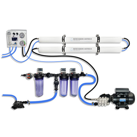
A two-membrane modular watermaker with 140 L/h nominal output, aimed at families and liveaboards that want more water per run.
Explore →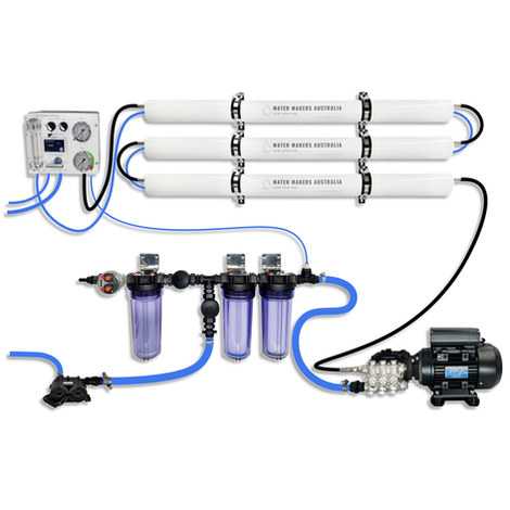
A three-membrane modular watermaker with 200 L/h nominal output and up to 240 L/h family-level marketing, for larger crews and heavy use.
Explore →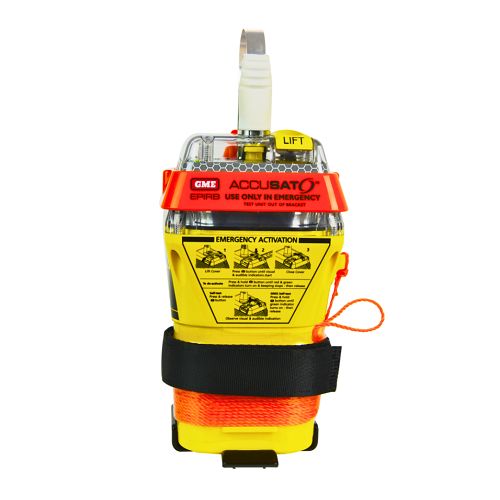
A 10‑year battery EPIRB with integrated GNSS (supports GPS and Galileo), infrared strobe and 121.5 MHz homing signal. Approved for worldwide COSPAS‑SARSAT operation.
Explore →
Self-contained, battery-powered plug‑and‑play autopilot designed for standard hydraulic steering systems.
Explore →