Loading this page…

Loading this page…
About
Strahan Wharf is a West Coast Council-owned working waterfront on Macquarie Harbour, including wharfage and marina berths. Ask council on (03) 6471 4700 about berth access. The waterfront and fuel arrangements are being redeveloped; an old claim of 24-hour card fuel at the wharf is not reliable current guidance.
Service area: Strahan, TAS
Keep exploring
The Strahan waterfront is a working wharf and marina-berth precinct serving fishing, tourism, aquaculture and visiting vessels on Macquarie Harbour. TasPorts transferred the wharf deck, marina berths, finger pier, little dock and related assets to West Coast Council in October 2023; MAST now lists council as the wharf owner. Council's 2026 redevelopment updates describe changes to wharf access, toilets and the fuel site, including investigation of temporary supply and a proposed relocation. Ask council about berth allocation and current fuelling before passage. Do not rely on historic TasPorts booking contacts or a 24-hour fuel claim.
Council owns the wharf deck, marina berths and associated waterfront assets. Enquire with West Coast Council on (03) 6471 4700 / wcc@westcoast.tas.gov.au about berth access, restrictions and charges. MAST lists diesel as a nearby service, but council's 2026 work affects the fuel site; current availability and hours must be confirmed directly. Public toilets and town services are nearby rather than assumed wharf-berth amenities.
Macquarie Harbour is entered through Hells Gates; plan around current weather and navigation notices. Strahan's waterfront is an active fishing/tour-boat precinct with redevelopment under way, so arrange a berth and check fuel access before making the passage.
Recently received AIS vessel positions around Strahan Wharf. The traffic display loads automatically.
Live traffic will appear after Strahan Wharf has verified map coordinates.
Bathurst Harbour (Port Davey system), in south‑west Tasmania, is a vast, almost land‑locked estuarine harbour inside the Southwest National Park and World Heritage Area. It offers a remote, sheltered anchoring environment protected from the Roaring Forties, but demands careful planning, an awareness of marine‑reserve rules, and a willingness to operate in shallow, tannin‑stained waters. Best suited to experienced coastal cruisers and small expedition yachts prepared for self‑sufficiency, Bathurst Harbour is more a place to linger and explore on foot and by tender than a port of call for busy,

Plan as a chain of conservative daily legs tied to your boat’s real-world fuel and speed in the expected sea state, with confirmed primary and alternate anchorages/berths, fuel legs and back-up fuel options, and a documented emergency/diversion plan (comms, tow and med-evac). Build tidal and weather gates into each leg and carry chart and comms redundancy.
Explore →
Yes — South Australian coastal waters include marine parks, aquatic reserves, harbour bylaws and local council restrictions that can affect anchoring, fishing, mooring and access; check the relevant state agencies, local councils and Notices to Mariners for location-specific rules and permit requirements.
Explore →
Taking pets between Australian states and into marinas or national parks is governed by state and territory biosecurity/quarantine rules, local council and marina policies, and the management rules of parks. Requirements vary by jurisdiction and by the species of animal, so check the relevant state/territory biosecurity office, the park management agency and the marina operator before you travel.
Explore →
Pick a ramp that matches your boat size and trailer setup, has safe approach and exit conditions (depth, slope, surface), good onshore parking and flow, and follow simple ramp etiquette: queue, help others, rig off the trailer when clear, and secure your vessel quickly.
Explore →A practical guide for recreational sailors planning visits to Albany and King George Sound. Covers the main anchorage areas, typical local weather patterns, tidal and current considerations, navigational hazards, on-the-water etiquette and a pre-departure checklist to help you plan a safe passage and enjoyable stopover
Explore →A practical guide to preparing, planning and executing a recreational offshore passage along the New South Wales coast. Covers route selection, weather and tidal considerations, vessel and crew checks, safety equipment, communication, watchkeeping and common mistakes, with clear pre‑departure and underway checklists.
Explore →
A practical guide for recreational sailors planning trips around the Capricorn Coast and Keppel Islands, covering seasonal considerations, common routes, anchorages, hazards, provisioning and sensible safety planning for Australian conditions.
Explore →
A practical guide for recreational sailors planning trips on the Gold Coast Broadwater: key features, local weather and tide considerations, navigation tips, common hazards, equipment checklist and step‑by‑step trip planning tailored to Australian conditions.
Explore →Burke Yachtsman Gear Bag 40L - Shop Now Zip Pay | Tamar Marine Skip to content 59 – 63 Holbrook Street, Invermay Online Shop Open 24/7 Products search Contact us 1300 MARINE $ 0.00 0 Cart Burke Yachtsman Gear Bag 40L $ 79.90 Colour Choose an option Black Blue Black Blue Clear - Burke Yachtsman Gear Bag 40L quantity + Add to cart Enquire about this product SKU BAGB-Y24/BLACK* Category Bags - Sail & Gear A Burke classic and customer favourite, the Yachtsman’s Gear Bag is built tough to handle wet, salty conditions while keeping your gear dry and protected. Made from double coated waterproof…
Explore →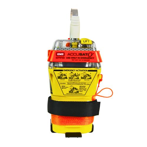
A 10‑year battery EPIRB with integrated GNSS (supports GPS and Galileo), infrared strobe and 121.5 MHz homing signal. Approved for worldwide COSPAS‑SARSAT operation.
Explore →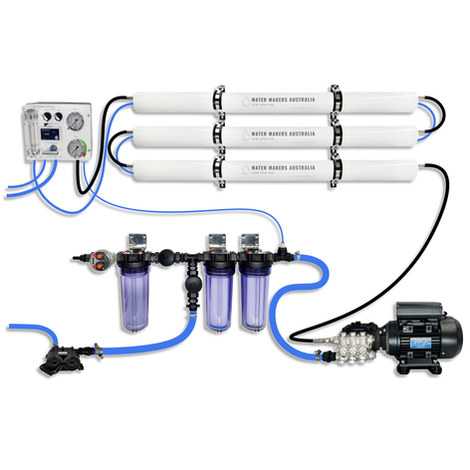
A three-membrane modular watermaker with 200 L/h nominal output and up to 240 L/h family-level marketing, for larger crews and heavy use.
Explore →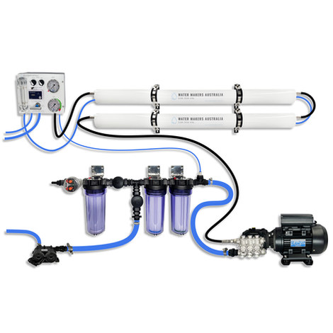
A two-membrane modular watermaker with 140 L/h nominal output, aimed at families and liveaboards that want more water per run.
Explore →