Loading this page…

Loading this page…
Marina service
About
Colmslie Wharves is a Brisbane River commercial marina development at Morningside, planned for 50 commercial berths, on-water fuel, pump-out, waste services and crew amenities.
Service area: Brisbane River (Morningside) — serving Brisbane CBD to Moreton Bay
Keep exploring
Use this listing for the commercial-vessel marina development on Colmslie Road. Current project material says the facility is under construction/planned for mid-2026, with 50 dedicated commercial-vessel berths, berth sizes from 12 m to 50 m, on-water fuelling, wastewater/pump-out, waste management, car parking and crew amenities.
The marina is planned around 51 berths dedicated to commercial vessels, with berth sizes running from 12m up to 35m; later project reporting describes the layout accommodating vessels to 50m, so prospective operators should confirm final berth dimensions with Raptis. Every berth is intended as a permanent home base rather than casual visitor mooring, and leasing is handled directly by the developer, with early commitments taken from local cruise and charter businesses displaced from the inner city.
On-water services are part of the design: fuel connection points allow refuelling at berth, sewage pump-out and general waste facilities are built in, and the project makes much of its environmental management, arguing that proper fuelling and wastewater infrastructure plus an end to unauthorised mooring will reduce pollution and riverbed damage on this reach.
Crew and operational needs are covered by staff amenities including toilets and showers, on-site car parking for vessel crews and provisioning vehicles, and easy road access for restocking, with most provisioning expected on weekends and outside business hours to suit the industrial setting. There is no shipyard, travel lift or chandlery on site; for haul-out and refit work operators will use Brisbane River facilities such as Rivergate at Murarrie.
The site is freehold industrial land with industry zoning that already supports marine uses, and its co-location with the Raptis seafood complex gives it a working-waterfront character rather than a resort-marina one. The developers also argue the facility will modernise the local commercial fleet, since operators have deferred vessel investment for years while berthing tenure was uncertain.
Colmslie sits on the south bank of the Brisbane River in the city's inner east, in a reach shared with tugs, barges and the steady commercial traffic of the Port of Brisbane downstream. Vessels berth in deep water alongside and enjoy straightforward navigation: the Gateway Bridges and the river mouth lie roughly a dozen kilometres downriver, putting Moreton Bay, the bay islands and their anchorages within easy day-trip range, while the city reaches, South Bank and the inner-city pick-up and drop-off pontoons are a short run upstream.
The brown snake, as locals call the river, runs murky and tidal here, with a range of around two metres and a noticeable ebb after rain, and shipping movements rather than weather are the main traffic consideration. Shore-side, this is an industrial precinct, which operators regard as an advantage after years of friction with residents at Dockside: there are no apartments overlooking the berths, and the nearest recreation space is Colmslie Recreation Reserve just along the river.
Crew change and provisioning logistics are simple, with the Port of Brisbane, airport and motorway network close by, and the Bulimba and Morningside dining strips a short drive for crew meals. For interstate operators eyeing Brisbane before the 2032 Games, Colmslie's selling point is certainty of tenure on a river that has not offered it to commercial vessels for years.
Commercial operators already based in Brisbane, from river cruise boats to charter catamarans, are expected to be the first tenants, with interstate entrants forecast to follow once the berths commission.
Satellite imagery at four heights, from the wider harbour to the berths.
Recently received AIS vessel positions around Colmslie Wharves. The traffic display loads automatically.
Live traffic will appear after Colmslie Wharves has verified map coordinates.
American River (Kangaroo Island, SA) is a small, sheltered inlet and township on the north‑eastern side of Kangaroo Island that acts as a calm staging point for cruising the eastern part of the island and for short hops through Backstairs Passage. It’s distinctive for its protected anchorage inside Eastern Cove and the adjacency of Pelican Lagoon — a shallow, ecologically important lagoon with sanctuary zoning — which shapes how and where boats can move. The area suits sheltered day sailing, weekend cruising and short coastal passages; it’s appropriate for trailer sailors, small cruisers and a

Plan passages across Spencer Gulf or to Kangaroo Island by basing fuel on your boat’s actual consumption plus a generous reserve, choosing sensible staging/stop options that match your boat and crew, and prioritising shelter and weather windows (gale fronts, strong winds and tidal streams can make the gulf uncomfortable or unsafe). Confirm fuel availability, safe anchorages or marinas on your route, and check up-to-date local weather, tide and navigation information before you go.
Explore →
Activate an EPIRB or PLB only when you are in grave or imminent danger and need search and rescue; use VHF and contact Marine Rescue for urgent help, to request assistance, or to relay information when you have time-critical but non-life-threatening problems.
Explore →
Plan as a chain of conservative daily legs tied to your boat’s real-world fuel and speed in the expected sea state, with confirmed primary and alternate anchorages/berths, fuel legs and back-up fuel options, and a documented emergency/diversion plan (comms, tow and med-evac). Build tidal and weather gates into each leg and carry chart and comms redundancy.
Explore →
Do a simple pre-departure check of fuel, oil, cooling, controls, battery and prop, plus a quick start-and-idle run to confirm the outboard is healthy and responds correctly before you leave the ramp.
Explore →A practical guide for recreational sailors on using VHF marine radios safely and effectively in Australian waters: basic operation, channel use, emergency procedures, DSC basics, common mistakes and a ready checklist for pre-departure and on-water use.
Explore →A practical guide for recreational sailors planning day sails or short cruises around Batemans Bay, Broulee and the Clyde River. Covers local conditions, safe approaches, anchorages, launching, tides, common hazards, and checklists for trip planning and on-water decisions.
Explore →Practical guide for recreational sailors planning passage on the Hawkesbury River: how to plan around tides, choose anchorages, read local conditions and prepare the boat and crew for a safe, comfortable trip.
Explore →Practical guide for recreational sailors navigating the Swan River and coastal waters around Perth. Covers local weather patterns, tides and currents, river navigation, launching and berthing options, safety equipment, common hazards, and step-by-step pre-departure and on-water checklists tailored to Western Australian
Explore →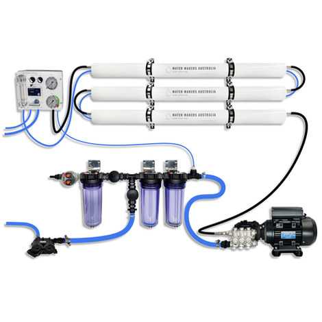
A three-membrane modular watermaker with 200 L/h nominal output and up to 240 L/h family-level marketing, for larger crews and heavy use.
Explore →Burke Yachtsman Gear Bag 40L - Shop Now Zip Pay | Tamar Marine Skip to content 59 – 63 Holbrook Street, Invermay Online Shop Open 24/7 Products search Contact us 1300 MARINE $ 0.00 0 Cart Burke Yachtsman Gear Bag 40L $ 79.90 Colour Choose an option Black Blue Black Blue Clear - Burke Yachtsman Gear Bag 40L quantity + Add to cart Enquire about this product SKU BAGB-Y24/BLACK* Category Bags - Sail & Gear A Burke classic and customer favourite, the Yachtsman’s Gear Bag is built tough to handle wet, salty conditions while keeping your gear dry and protected. Made from double coated waterproof…
Explore →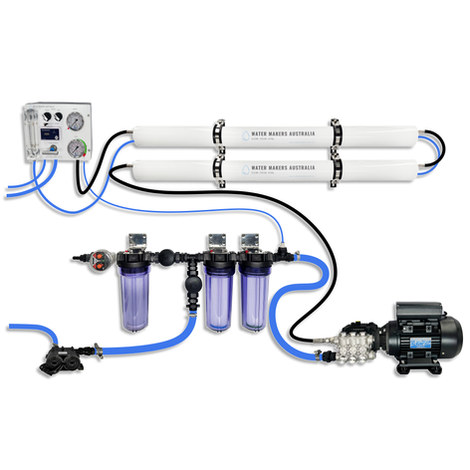
A two-membrane modular watermaker with 140 L/h nominal output, aimed at families and liveaboards that want more water per run.
Explore →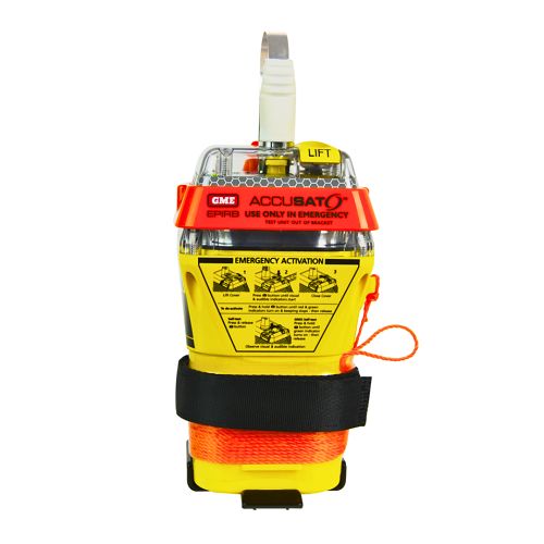
A 10‑year battery EPIRB with integrated GNSS (supports GPS and Galileo), infrared strobe and 121.5 MHz homing signal. Approved for worldwide COSPAS‑SARSAT operation.
Explore →