Loading this page…

Loading this page…
Marina service
About
Dundee Beach Boat Ramp & Jetty is a public Top End launching facility near Dundee Beach Holiday Park, with tidal access, ramp sediment considerations and Bynoe Harbour fishing access.
Service area: Dundee Beach, NT
Keep exploring
Use this listing as a public ramp/jetty facility rather than a marina. NT ramp information notes the Dundee Beach ramp is accessible at tides above about 2.8 m and sediment build-up can occur, while local sources describe a public ramp by the holiday park and a high-capacity concrete launch ramp with floating walkway/pontoon context.
Everything here is free public access, and the services list is honestly short because Dundee is a ramp and jetty, not a berthing facility. The wide concrete boat ramp gives deep-water launching into Fog Bay and is rated by the NT Government as accessible at tides above 2.8 metres, with an official caveat that sediment build-up can occur and users should check current conditions before travelling.
The 2025 upgrade added the walkway jetty, which permits short-term mooring alongside so one crew can hold a boat off while another parks the trailer, plus the reconstructed groyne, a land-based fishing platform and an accessible footpath. There is a large car and trailer parking area; there are no berths, no power or water, and no fuel at the ramp itself. Heavy offshore boats too big to float on and off a trailer in the shallows are handled by commercial tractor launching operators working the tides, a Dundee specialty born of the seven-metre tidal range.
The nearest fuel, food and a licensed bar are at Dundee Lodge (Native Point) close by, with a general store and tackle outlet on Namarada Drive and a social club for a counter meal. Dundee Beach Volunteer Marine Rescue is based in the settlement and monitors VHF channels 16, 73, 80 and 88, a genuine safety net in a location with no mobile coverage guarantees.
Accommodation within minutes of the ramp includes the Dundee Beach Holiday Park, Dundee Lodge and smaller retreats, and several fishing charter operators base themselves here through the May-to-December season.
Tide planning rules everything at Dundee. With a range past seven metres, locals consult the tide chart before they consult the weather; arriving at the ramp below about 2.8 metres of tide means waiting on the concrete, and some skippers quote nearer 3.3 metres as comfortable for bigger rigs. From the ramp, Bynoe Harbour opens to the south with its mangrove creeks, deep mud channels and artificial reefs like Crab Claw Jetty and Simms Reef holding black jewfish and golden snapper, while the Peron Islands reef system lies about 15 nautical miles offshore in 10 to 30 metres for red emperor and coral trout.
The Finniss River mouth, noted for barramundi, threadfin salmon and mud crabs, is roughly a 35-minute run along the coast. The run-off months from March to May concentrate barra at the creek mouths; the dry season suits the reefs and pelagics. NT bag limits apply and are enforced: five barramundi per person at 55 centimetres minimum, black jewfish limited to two at 60 centimetres. Crocodile awareness is non-negotiable at the ramp, on the beach and around every creek mouth; never wade to the trailer, and keep clear of the water's edge when launching.
Sand movement around the groyne is a known maintenance issue despite the rebuild, so conditions can change between visits. The drive from Darwin takes about two hours on sealed road, and the ramp's popularity means dry-season Saturdays see queues at first light. When the Dundee ramp is tide-bound or crowded, Six Mile Creek and Milne Inlet ramps into Bynoe Harbour are the fallback options, each with their own tidal minimums.
Mobile phone coverage around the boat harbour is patchy, so filing a trip plan with VMR Dundee before heading offshore is standard local practice.
Satellite imagery at four heights, from the wider harbour to the berths.
Recently received AIS vessel positions around Dundee Beach Boat Ramp & Jetty. The traffic display loads automatically.
Live traffic will appear after Dundee Beach Boat Ramp & Jetty has verified map coordinates.
Ballina sits at the mouth of the Richmond River on NSW’s far‑north coast. It’s a working river entrance with a compact boat harbour, exposed ocean beaches and a changeable, sand‑dominated bar. For coastal cruisers it offers a useful stop between Tweed Heads and Yamba, sheltered estuary cruising upriver and easy access to open ocean passages — but the river entrance is highly condition‑dependent and demands respectful planning and local knowledge.

Use ramps and beaches with respect for local conditions: check ramp layout, tide and swell, wind direction, vehicle access and crowding; prepare boat and crew before you launch or retrieve; and follow local signage, courtesy and safety practices. Specifics vary by ramp and beach, so confirm details for the exact site before you go.
Explore →
Pick a ramp that matches your boat size and trailer setup, has safe approach and exit conditions (depth, slope, surface), good onshore parking and flow, and follow simple ramp etiquette: queue, help others, rig off the trailer when clear, and secure your vessel quickly.
Explore →
Plan to use tide and local knowledge, slow and steerable power, and deliberate positioning to work with—rather than fight—strong streams and eddies when entering or leaving Tasmanian harbours.
Explore →
Local rules, marine‑park zoning and permit needs vary by reserve around South Australia’s coast — check the relevant marine park zoning map and SA Department for Environment and Water (DEW) information for the exact area before you go.
Explore →Practical guide for recreational sailors in Pittwater covering safe anchorages, popular beaches, typical weather patterns, tidal and local considerations, boat handling and a pre-departure checklist tailored to local conditions.
Explore →A practical guide for recreational sailors planning passages to, from or around Eden and Twofold Bay. Covers sheltered anchorages, shore facilities, local weather and tidal considerations, preparing for Bass Strait conditions and a focused equipment and safety checklist.
Explore →A practical guide to preparing, planning and executing a recreational offshore passage along the New South Wales coast. Covers route selection, weather and tidal considerations, vessel and crew checks, safety equipment, communication, watchkeeping and common mistakes, with clear pre‑departure and underway checklists.
Explore →
A practical guide for recreational sailors in Australia explaining how tides and currents work, how tidal gates (entrance bars, harbour gates and man-made locks) affect navigation, and how to plan passages and manoeuvres safely around tidal influences.
Explore →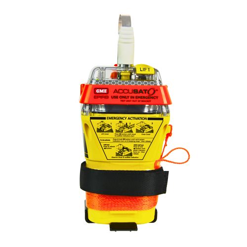
A 10‑year battery EPIRB with integrated GNSS (supports GPS and Galileo), infrared strobe and 121.5 MHz homing signal. Approved for worldwide COSPAS‑SARSAT operation.
Explore →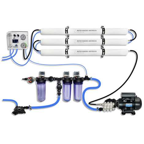
A three-membrane modular watermaker with 200 L/h nominal output and up to 240 L/h family-level marketing, for larger crews and heavy use.
Explore →Burke Yachtsman Gear Bag 40L - Shop Now Zip Pay | Tamar Marine Skip to content 59 – 63 Holbrook Street, Invermay Online Shop Open 24/7 Products search Contact us 1300 MARINE $ 0.00 0 Cart Burke Yachtsman Gear Bag 40L $ 79.90 Colour Choose an option Black Blue Black Blue Clear - Burke Yachtsman Gear Bag 40L quantity + Add to cart Enquire about this product SKU BAGB-Y24/BLACK* Category Bags - Sail & Gear A Burke classic and customer favourite, the Yachtsman’s Gear Bag is built tough to handle wet, salty conditions while keeping your gear dry and protected. Made from double coated waterproof…
Explore →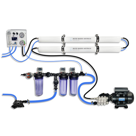
A two-membrane modular watermaker with 140 L/h nominal output, aimed at families and liveaboards that want more water per run.
Explore →