Loading this page…

Loading this page…
Marina service
About
Snapper Creek Boat Harbour at Norman Point is a state-managed Tin Can Bay boat harbour and public boating area with ramp/pontoon access nearby.
Service area: Tin Can Bay, Cooloola Coast, QLD
Keep exploring
Use this listing for Snapper Creek / Norman Point as a state-managed boat harbour and public boating precinct, not a private marina. Queensland publications identify Snapper Creek as a state boat harbour at Tin Can Bay, while local references note deep-water ramp and floating pontoon access at Norman Point.
Facilities are public and practical. The dual-lane ramp launches into deep water at most tides and is backed by a floating boarding pontoon, generous car-and-trailer parking and fishable public pontoons; a smaller single-lane ramp at nearby Crab Creek serves as an alternative, and Bullock Point, closer to the Wide Bay Bar at Inskip, is preferred by offshore boats. The commercial wharf - the professional wharf, as locals call it - handles the trawler fleet and is worth a stroll, with the Lee Fishing Company selling local prawns, scallops and crabs nearby.
Coast Guard Tin Can Bay operates its radio room at the ramp from about 5:30 or 6am to 6pm daily, taking log-ons in person, on VHF channel 80 or by phone; the service is free, and the volunteers hold trip details, destination and return time so an overdue boat triggers a search. Their Marine Assist membership, roughly $65 to $110 a year depending on operating range from Snapper Creek, buys two free tows or assists annually - cheap insurance on a waterway with notorious bars.
The services building at the harbour houses the Coast Guard, Tin Can Bay Houseboats for dinghy and houseboat hire, and Barnacles Cafe at the head of the dock, while the yacht club serves lunch Wednesday to Sunday and dinner on Fridays. There is no fuel berth at the harbour itself; skippers fuel at the nearby Tin Can Bay Marina or at road servos in town. Rubbish disposal, public toilets and barbecue facilities sit in the adjacent council parkland, and an IGA supermarket, library with wifi and the foreshore walking trail are all within easy walking distance of the pontoons.
Every conversation about boating here starts with the Wide Bay Bar, the shallow, shifting entrance between Inskip Point and the southern tip of K'gari that guards Tin Can Inlet. It is one of Queensland's most respected bar crossings, and the Coast Guard at Norman Point holds current waypoints and local advice - call them on channel 80 before attempting it, cross on a making tide in settled weather, and treat the leads as a guide rather than a guarantee because banks move after every big blow.
Inside, the marked channel up Snapper Creek to the harbour is straightforward, though anchoring within the creek itself is not permitted; visiting yachts usually pick up local moorings in about 20 feet of water with good holding, or berth up the creek at Tin Can Bay Marina. Tidal streams run hard in the inlet and currents are a fact of life at anchor. The rewards are immediate: sheltered sailing up the Great Sandy Strait toward Fraser Island's western anchorages, crabbing in the creek arms, and tailor fishing off the northern beaches that draws hundreds of anglers when the schools are on.
Dolphins are the town's signature - the regulated feeding program runs at Norman Point between about 7 and 8:30am on a first-in basis - and migrating whales pass the coast from June to October. Ashore, Tin Can Bay keeps an unpretentious fishing-town rhythm: markets on the third Saturday of the month, the four-kilometre foreshore bird walk with more than 130 recorded species, a country club, bowls and a couple of honest pubs.
Satellite imagery at four heights, from the wider harbour to the berths.
Recently received AIS vessel positions around Snapper Creek Boat Harbour (Norman Point). The traffic display loads automatically.
Live traffic will appear after Snapper Creek Boat Harbour (Norman Point) has verified map coordinates.
Dangar Island sits in the lower Hawkesbury River close to Brooklyn and is one of Sydney’s small, boat‑access communities. From the water it reads as a wooded, low island with sandy foreshore, a public jetty and private moorings; its position at the mouth of Cowan Creek and close to the main river channel makes it an attractive short‑cruise destination for trailer sailors, runabouts and small cruisers but also one that requires careful local knowledge and respect for resident berths, ferry operations and tidal currents.

Use ramps and beaches with respect for local conditions: check ramp layout, tide and swell, wind direction, vehicle access and crowding; prepare boat and crew before you launch or retrieve; and follow local signage, courtesy and safety practices. Specifics vary by ramp and beach, so confirm details for the exact site before you go.
Explore →
Tasmania has a mix of state marine parks, local harbour bylaws and environmental protections that affect where and how you anchor—so check the specific area’s rules before you go, aim to use designated anchorages or soft seabeds, and follow standard anchoring and biosecurity good practice.
Explore →
Maybe — it depends. In NSW you often need registration and a boat operator licence for motorised vessels, but many small trailerable sailing dinghies without engines don’t require boat registration or a licence. Check the specific rules for your craft, trailer and engine.
Explore →
Treat a southerly buster as a rapid-onset windshift with a strong increase in wind and sea state; prepare the boat and crew by reducing sail area early, securing loose gear, briefing crew on roles, and identifying shelter or an upwind recovery plan. Respond quickly but deliberately — keep boat controllable, avoid last-minute heavy-handed moves, and prioritise mainsail and crew safety over speed.
Explore →A practical guide for recreational sailors planning passages to, from or around Eden and Twofold Bay. Covers sheltered anchorages, shore facilities, local weather and tidal considerations, preparing for Bass Strait conditions and a focused equipment and safety checklist.
Explore →A practical guide for recreational sailors planning voyages to Esperance and the Recherche Archipelago: what to expect, key planning considerations, common anchorages, safety and communications, equipment recommendations and sensible steps for a successful trip in this remote southern WA cruising area.
Explore →A practical guide for recreational sailors on using VHF marine radios safely and effectively in Australian waters: basic operation, channel use, emergency procedures, DSC basics, common mistakes and a ready checklist for pre-departure and on-water use.
Explore →A practical guide for recreational sailors planning trips around Shark Bay, focusing on Denham, Dirk Hartog Island and nearby protected anchorages. Covers local conditions, route planning, anchoring, hazards, tides, wildlife considerations and sensible trip planning for coastal cruising in this unique West Australian,́
Explore →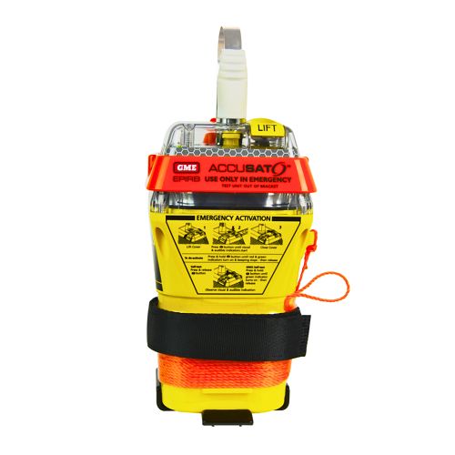
A 10‑year battery EPIRB with integrated GNSS (supports GPS and Galileo), infrared strobe and 121.5 MHz homing signal. Approved for worldwide COSPAS‑SARSAT operation.
Explore →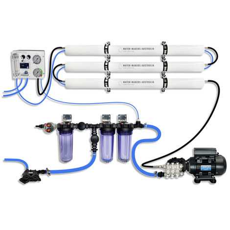
A three-membrane modular watermaker with 200 L/h nominal output and up to 240 L/h family-level marketing, for larger crews and heavy use.
Explore →
Self-contained, battery-powered plug‑and‑play autopilot designed for standard hydraulic steering systems.
Explore →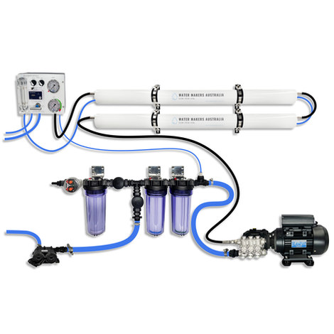
A two-membrane modular watermaker with 140 L/h nominal output, aimed at families and liveaboards that want more water per run.
Explore →